NOAA forecast cone shows major hurricane landfall in Florida on Wednesday
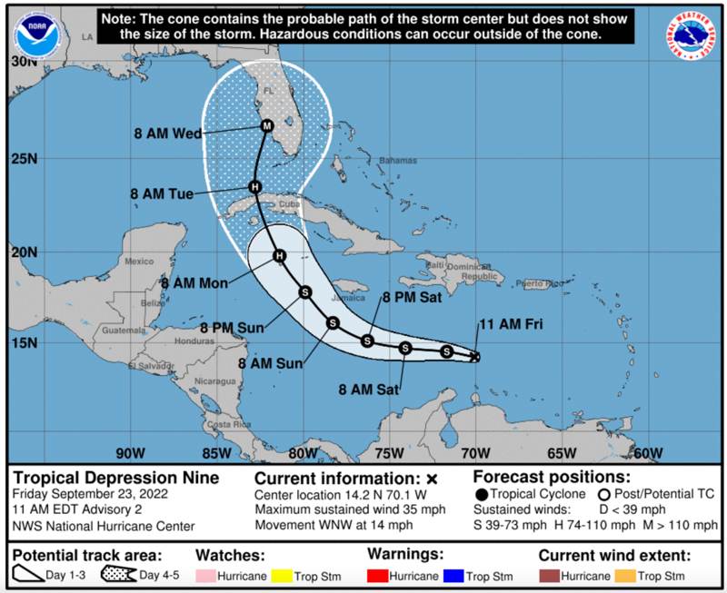
An update to the forecast cone for developing tropical depression 9, which is expected to become tropical storm Hermine and then hurricane Hermine, now depicts a scenario no one in the insurance, reinsurance, catastrophe bond, or ILS market wants to see, a major category hurricane landfall in Florida.
Once again, a forecast this far out is fraught with uncertainty and lacking in skill, but the update to NOAA’s forecast cone just now means we see the first forecast cone depicting a major Florida hurricane landfall in some years.
The cone showing a major hurricane landfall for Florida’s west coast can be seen below (view a live tracking map here):
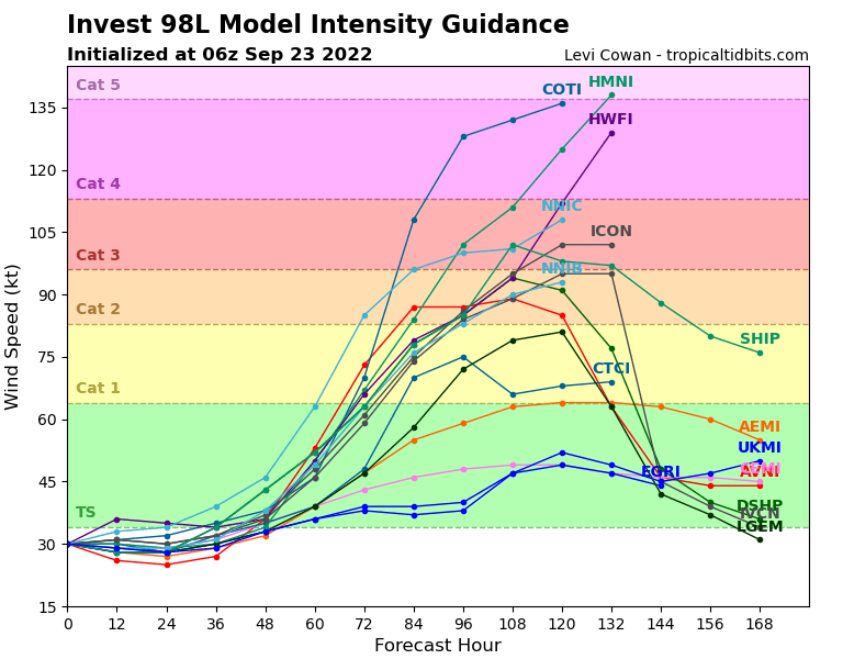
There is still some uncertainty over whether tropical depression 9 becomes storm and then hurricane Hermine, or Ian, although the majority of forecasts seem to suggest Hermine as the most likely still.
Below you can see the latest modelled intensity guidance for 98L (Hermine or Ian), also from TropicalTidbits.com:
Florida is now considered to be the most likely destination for this storm once it has developed and intensified over the Caribbean.
There’s still some spread in the models and so a relatively wide forecast cone at this time, but the general model consensus has now shifted towards the Florida solution.
How intense a hurricane this storm, Hermine or Ian, may become, could have a lot to do with how impactful it is to Cuba’s western region.
The mountainous west side of Cuba has the potential to hinder a storm’s formation, but it should be noted we’ve also seen hurricanes that easily cross Cuba without losing too much power on the way.
The latter seems to the the solution that models are currently leaning towards, with a still strong, roughly Category 2 hurricane expected to emerge into the southern Gulf of Mexico and then intensify rapidly on approach to Florida, somewhere around the Naples, Fort Myers, to Sarasota area of coastline on the west of the Peninsula.
That’s a region with plenty of insured exposure, so any major hurricane landfall there certainly has the potential to be a double-digit billion dollar loss event, with significant ramifications for the insurance, reinsurance and ILS community.
But we’re still a long way off having any certainty over the forecast and this storm could take a different direction, be weakened by Cuba, fail to intensify as much as the models currently expect, or encounter more wind shear than anticipated, all of which could change the direction, the strength and ultimately the landfall scenario.
There is a lot that could change between now and next Wednesday.
That said, it’s worth repeating that this is the first forecast cone showing a major Florida hurricane landfall event in some time, so definitely worth taking seriously.
While we know some live cat related rumours are floating around the market (they always do), it’s never really a news that you could get quoted for some protection.
What is always more surprising is that anyone can afford to, or is motivated to, buy and right now it seems still too early.
With the weekend approaching though, the usual conundrum presents itself, that come Monday it could be too late for any live cat capacity buying as well. With the greater certainty on the outcome that we’re likely to see after the weekend, either the need for protection dissipates, or the price rises to a level that makes it completely unfeasible to buy that kind of coverage.
As a result, it’s shouldn’t come as a surprise if there’s live cat trading chatter in the market, but it will be surprising if anyone actually does any deals.
Right now NOAA suggests that the earliest that tropical storm force winds could arrive in Florida would be on Monday, although it may be later by the time Cuba has been navigated by this storm (Hermine, Ian, or whatever tropical depression 9 is eventually named).
Track the 2022 Atlantic tropical storm and hurricane season on our dedicated page and we’ll update you as new information emerges.